
California’s Sierra Nevada mountains offer some of the most memorable road trips in the American West, and State Route 108 is one of the region’s most rewarding scenic drives. Running east from the Sonora area through mountain communities, forested landscapes, recreational destinations, and high-elevation terrain, Highway 108 gives travelers an opportunity to experience a different side of California beyond its crowded coastal cities and major national park gateways.
The highlight of this route is Sonora Pass, a spectacular mountain crossing surrounded by rugged granite formations, alpine scenery, evergreen forests, and sweeping views across the Sierra Nevada. At an elevation of approximately 9,624 feet, Sonora Pass is one of California’s highest paved mountain crossings and an unforgettable destination for travelers who enjoy photography, outdoor recreation, and quiet mountain landscapes.
However, a trip along Highway 108 requires more planning than an ordinary highway drive. Weather conditions can change rapidly at higher elevations, services become less frequent as the road climbs, and the pass closes seasonally because of snow. Travelers who understand the route, plan suitable stops, and check current road conditions can enjoy a safer and more rewarding adventure.
This guide explores the best scenic stops along Highway 108, the landscapes that make Sonora Pass special, nearby outdoor activities, seasonal driving considerations, and practical advice for planning a memorable Tuolumne County road trip.
Why Highway 108 Is Worth Exploring
Highway 108 connects the communities and landscapes of the western Sierra Nevada with the mountain country east of Sonora Pass. Along the way, the scenery changes dramatically, making the drive feel like several different trips combined into one.
The western portion passes through foothill communities, wooded areas, and forested mountain terrain. As the highway climbs, travelers encounter cooler temperatures, recreational lakes, river corridors, granite slopes, and increasingly expansive views. Beyond the high pass, the environment transitions into the eastern Sierra landscape, where open slopes and rugged mountains create a striking contrast with the dense forests farther west.
This variety makes the highway appealing to photographers, hikers, campers, families, motorcyclists, and travelers who simply enjoy scenic driving. You do not need to complete a strenuous hike to appreciate the route. Many of its most memorable views can be enjoyed through carefully chosen roadside stops and short walks where parking and access are permitted.
Highway 108 also provides an opportunity to explore communities that serve as gateways to the Sierra Nevada. Sonora, Twain Harte, Mi-Wuk Village, and Strawberry offer different ways to experience the region, from historic downtown streets and small-town businesses to forest retreats and outdoor recreation.
The best approach is to treat the journey as a destination rather than rushing directly toward the summit. Allowing time for viewpoints, local food, photographs, and short outdoor excursions can turn a few hours behind the wheel into a complete mountain getaway.
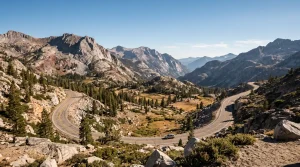 Start Your Journey in Sonora, California
Sonora is an excellent starting point for a Highway 108 road trip. Located in Tuolumne County, this historic community offers restaurants, shops, lodging, and access to the scenic mountain country farther east.
Before leaving town, consider walking through downtown Sonora. Historic buildings, independent businesses, and Gold Rush-era character make the community worth exploring even if your primary goal is the mountain drive. Visitors can pick up snacks, water, and other essentials before heading into areas where services may be limited.
Sonora is also a convenient place to review your route, check the weather forecast, and make sure your vehicle is ready for mountain driving. Fueling up before climbing toward the higher elevations is a sensible precaution, particularly if you intend to continue across the pass and travel toward U.S. Route 395.
The journey can be completed as a day trip when the road is open, but a longer itinerary offers more flexibility. Spending a night in the Sonora area allows you to explore local attractions without rushing, while an overnight stay closer to the mountains can make it easier to enjoy early-morning photography and quieter roadside stops.
Travelers interested in local history can also explore related stories about Tuolumne County’s Gold Rush communities and historic downtown districts. These attractions add cultural context to a trip that might otherwise focus entirely on mountain scenery.
Twain Harte and the Forested Foothills
Continuing east along Highway 108, travelers reach the general area of Twain Harte, a small mountain community known for its forested setting and relaxed Sierra Nevada atmosphere.
This is a useful place to slow down before the road climbs into more remote terrain. Depending on the season and individual business hours, visitors may find places to eat, browse local shops, or take a short break before continuing toward the higher elevations.
The surrounding landscape is especially attractive to travelers who enjoy tall trees, shaded roads, and the transition from foothill country into the mountains. During warmer months, the forest can provide a welcome change from the heat of California’s Central Valley.
Twain Harte also works well as a base for visitors who want to divide a longer drive into manageable sections. Instead of attempting the entire route in one continuous journey, you can spend time exploring the community before heading farther east the following morning.
Keep in mind that roadside facilities and businesses do not necessarily operate year-round. Check opening hours before making a particular restaurant, store, or service stop an essential part of your itinerary.
Mi-Wuk Village and the Highway 108 Mountain Corridor
Mi-Wuk Village is another useful stopping point along the western approach to Sonora Pass. The community sits within the forested mountain corridor and provides a sense of the residential and recreational areas that support visitors to the Stanislaus National Forest.
The surrounding environment offers a quieter experience than many heavily visited California destinations. Trees, mountain air, and winding roads define much of the landscape, while the highway connects the community with other Sierra Nevada recreation areas.
Visitors should use established parking areas and respect private property when looking for places to pause and photograph the scenery. Not every attractive forest clearing is a public recreation site, and stopping along narrow highway shoulders can create unnecessary hazards.
As you travel farther east, the route becomes increasingly focused on outdoor recreation. The availability of fuel, food, drinking water, and other services becomes more limited, so this is a good stage of the journey to confirm that you have everything necessary for the remainder of your drive.
For travelers who enjoy exploring small California mountain towns, Mi-Wuk Village can be part of a broader Tuolumne County itinerary that includes local businesses, forest recreation, and historic communities.
Strawberry and the South Fork Stanislaus River Area
Strawberry is an important reference point for travelers approaching the upper Highway 108 corridor. Located near the South Fork Stanislaus River and surrounded by forested mountain scenery, the area provides a transition between the more developed western communities and the higher-elevation landscape leading toward Sonora Pass.
The river corridor adds another dimension to the road trip. Water, granite, evergreen trees, and mountain slopes create scenic combinations that are particularly attractive for landscape photography. Depending on access conditions, visitors may find opportunities to enjoy the scenery from established recreation areas or designated stopping points.
Water safety is important in mountain rivers. Even when the weather is warm, snowmelt-fed water can remain extremely cold, and currents can be stronger than they appear. Slippery rocks, sudden changes in depth, and submerged obstacles can also make entering the water dangerous.
Choose established access points and observe posted warnings. Never assume a river is safe for swimming simply because other visitors are standing nearby.
Strawberry is also a reminder that mountain weather can differ considerably from conditions in Sonora or the Central Valley. Temperatures may drop quickly after sunset, and rain or snow can arrive even when lower elevations remain dry.
Before continuing uphill, check the latest highway report and weather forecast. This is particularly important in late fall, winter, and spring, when conditions can change rapidly along the upper route.
Pinecrest Lake: A Scenic Stop Near Highway 108
Pinecrest Lake is one of the best-known recreational destinations in the Highway 108 corridor and a natural choice for travelers who want to combine a scenic drive with time outdoors.
Surrounded by forested slopes, the lake offers a beautiful setting for photography, picnicking, walking, and seasonal water-based recreation. Its shoreline scenery makes it appealing to families and visitors who want to experience the Sierra Nevada without committing to a demanding mountain hike.
During warmer months, visitors may enjoy walking near the water, taking photographs of reflections, or relaxing at designated picnic areas. Boating and other activities depend on seasonal operations, available facilities, and current rules, so check local information before planning around a particular activity.
The lake is particularly attractive in the morning, when calm water and softer light can create excellent photography conditions. Later in the day, changing sunlight can illuminate the surrounding forest and mountain slopes in different ways.
Pinecrest can also serve as a destination in its own right. If you have only one day available, consider spending a substantial part of it around the lake rather than trying to visit every stop along Highway 108.
Parking availability, recreation fees, campground reservations, and seasonal services may vary. Summer weekends can be busy, making an early arrival a practical strategy for visitors who prefer quieter surroundings.
Because Pinecrest is a recreation destination rather than simply a roadside viewpoint, it deserves time in your itinerary. A leisurely walk, a picnic, and a few hours enjoying the landscape can provide a welcome break from driving.
Kennedy Meadows: A Gateway to High-Country Scenery
Farther east, Kennedy Meadows is associated with the transition into the more rugged and remote section of the Highway 108 corridor. The surrounding landscape reflects the appeal of the high Sierra, where outdoor recreation, mountain views, and access to backcountry areas attract hikers, campers, and other outdoor enthusiasts.
This area can be a useful stop for travelers who want to appreciate the mountain environment before continuing toward Sonora Pass. Depending on current access and operating conditions, visitors may find opportunities to explore established recreation facilities or enjoy the surrounding scenery.
Kennedy Meadows is also relevant to hikers traveling sections of the Pacific Crest Trail and other routes in the broader region. However, visitors should distinguish between a roadside sightseeing trip and a backcountry excursion. Trail travel may require additional preparation, navigation, sufficient water, and awareness of weather and elevation.
Facilities in mountain areas may be seasonal or limited. Do not assume that fuel, food, drinking water, or other supplies will be available whenever you arrive. Check the operating status of any business or recreation facility you intend to use.
Large recreational vehicles and vehicles towing trailers should also exercise particular caution before attempting the steep, winding upper route. The road becomes more challenging as it approaches Sonora Pass, and not every vehicle combination is well suited to the narrowest sections.
Kennedy Meadows is best enjoyed as part of a carefully planned trip, with enough time to appreciate the scenery and enough flexibility to turn around if road or weather conditions make further travel inadvisable.
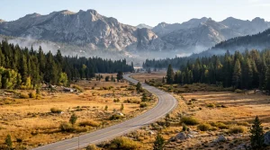 Sonora Pass: The Highlight of the Road Trip
Sonora Pass is the defining destination on Highway 108. At approximately 9,624 feet above sea level, the summit offers a dramatic introduction to the high Sierra Nevada, with rugged peaks, exposed granite, alpine vegetation, and sweeping mountain views.
Unlike a heavily developed tourist destination, the pass is primarily about the landscape itself. The surrounding terrain feels expansive and exposed, particularly after the forested approach from the west. On clear days, the combination of rocky slopes, distant ridgelines, and open skies creates outstanding opportunities for photography.
The summit area also connects with trails and recreation opportunities in the surrounding mountain environment. The Pacific Crest Trail crosses the region, and hikers may be able to explore suitable sections when access and conditions permit. Always verify the location of trailheads, parking arrangements, and current trail information before setting out.
Because the pass sits at high elevation, visitors should expect cooler temperatures, stronger winds, and potentially intense sunlight. Even during summer, a jacket and sun protection can make the experience more comfortable.
Take time to appreciate the view, but avoid stopping in unsafe locations or obstructing traffic. Use designated parking and established pullouts where available, and keep a safe distance from steep slopes and exposed edges.
It is also important to understand that reaching the summit does not guarantee that the highway is open all the way through to the eastern side. Seasonal closures can prevent travel across the pass even when lower portions of Highway 108 remain accessible.
For travelers planning a complete west-to-east crossing, confirming the status of the entire route is essential before departure.
Leavitt Meadow and the Eastern Approach
On the eastern side of Sonora Pass, the landscape changes again. The terrain opens into a high-country environment where meadows, mountain slopes, and broad views create a different visual experience from the dense forests west of the summit.
Leavitt Meadow is a notable recreation area in this broader eastern section of the route. When access is available, the surrounding scenery can be appealing for photography, nature observation, and travelers seeking a quieter mountain setting.
The meadow environment also illustrates how elevation and exposure shape Sierra Nevada ecosystems. Forests become more intermittent, open ground becomes more prominent, and the relationship between mountain slopes and valley floors becomes easier to appreciate.
Visitors should remain on established routes and avoid trampling sensitive vegetation. Meadows and streamside areas can be particularly vulnerable to damage from vehicles, informal trails, and careless camping practices.
Conditions in this region can differ from those at the summit or on the western approach. Before planning a stop, confirm road access, weather conditions, and any relevant land-management restrictions.
If your itinerary continues toward U.S. Route 395, allow enough daylight for the remaining drive. Mountain roads can take longer than expected, and stopping frequently for photographs can add considerable time to the journey.
Travelers who do not need to complete the entire crossing can instead make the open western portion of Highway 108 their destination and return the way they came when conditions permit. This can be the better choice when daylight, weather, or vehicle suitability is a concern.
Scenic Photography Along Highway 108
Highway 108 provides a wide range of photographic subjects, from small-town details and forest roads to alpine landscapes and distant mountain ridgelines.
The most effective approach is to think about the changing environment rather than looking for a single perfect viewpoint. In the foothills, focus on the relationship between roads, trees, and mountain communities. Around the river corridor, look for natural contrasts between water, rock, and forest. Near Pinecrest Lake, reflections and shoreline details can create a more intimate style of landscape photography.
At higher elevations, wide-angle compositions can capture the scale of the terrain, while a longer focal length can help isolate distant peaks and interesting rock formations. Early morning and late afternoon often provide softer light, but changing mountain weather can produce striking conditions throughout the day.
Fall color, snow-covered slopes, summer wildflowers, and fresh spring growth can each create different visual opportunities. However, seasonal appearances vary with elevation and annual weather patterns. Avoid promising yourself a particular display without checking recent local conditions.
Safety should always come before the photograph. Never stand in a traffic lane, stop around a blind curve, or step onto an unstable slope to improve a composition. Pull completely into a safe, legal stopping area before getting out of your vehicle.
Respect other visitors and the natural environment. Pack out trash, avoid damaging plants, and do not leave established paths to approach fragile alpine areas.
Seasonal Driving Tips for Highway 108 and Sonora Pass
The season you choose can determine whether you experience a straightforward scenic drive or encounter substantial travel restrictions. Sonora Pass is a high-elevation mountain crossing, and its operating season depends on snow accumulation, spring weather, road maintenance, and safety assessments.
Spring: Watch for Reopening Updates
Spring can bring a dramatic transformation to the Sierra Nevada, but it does not guarantee that Sonora Pass will be open. Snow may remain deep at high elevations after lower mountain communities have warmed, and road crews need time to clear snow and address hazards.
In 2026, Caltrans announced a seasonal reopening of Sonora Pass on April 30, followed by further winter-weather-related reopening information in early May. This illustrates why travelers should rely on current official notices rather than assuming the road opens on the same date every year. See the Caltrans mountain-pass information for seasonal updates.
Even after reopening, drivers should watch for icy surfaces, debris, lingering snowbanks, and changing weather. Early-morning conditions can be very different from those in the afternoon.
Summer: The Classic Scenic-Drive Season
Summer is generally the most practical season for a full Sonora Pass road trip, provided the highway is officially open and weather conditions are suitable. Snow clearance typically makes more of the high-elevation route accessible, while warmer weather supports hiking, picnicking, photography, and visits to recreational lakes.
Nevertheless, summer does not eliminate mountain-driving challenges. The road includes sharp turns, steep grades, exposed stretches, and limited shoulders. Afternoon thunderstorms can develop in mountain terrain, and popular recreation areas may have busy parking lots.
Carry drinking water, sun protection, a light jacket, and enough food for delays. Check for wildfire-related restrictions, smoke, and road closures before leaving, particularly during periods of elevated fire danger.
Fall: Beautiful Views and Changing Weather
Fall can be an excellent time to explore the lower and middle elevations of Highway 108. Cooler temperatures and seasonal color may create attractive conditions for photography and quiet mountain outings.
However, the high country can experience winter-like weather before the foothills do. Snowfall can occur at high elevations in autumn, and a storm may temporarily restrict travel or signal the approach of the seasonal closure period.
If you are planning a fall trip, keep your itinerary flexible and verify conditions shortly before departure. Do not assume that a pass that was open last week will remain open after a significant storm.
Winter: Understand the Seasonal Closure
Sonora Pass closes seasonally because of snow and hazardous conditions. During closure periods, travelers cannot complete the full Highway 108 crossing over the summit, although some lower sections may remain accessible from either side.
As of October 22, 2026, the Caltrans highway report lists the Sonora Pass section as closed because of snow. Travelers planning a trip at this time should not assume they can cross the pass. Check the official SR 108 road report immediately before travel and use a suitable alternate route if the crossing is closed. <Cite refs={[“turn823201search0″,”turn823201search3”]}/>
Winter driving in the Sierra Nevada may involve snow, ice, chain controls, reduced visibility, and rapidly changing conditions. If you intend to visit an accessible lower-elevation area, prepare for winter travel and follow all posted restrictions. Never attempt to bypass a closure gate or continue onto a road that authorities have closed.
Essential Safety Advice for Mountain Drivers
A scenic mountain road requires attention to vehicle condition, speed, weather, and the behavior of other road users. Before starting your trip, check your tires, brakes, lights, fuel level, windshield wipers, and coolant system. A vehicle that performs well on flat highways may feel very different on steep grades and tight mountain curves.
Drive at a speed that allows you to remain in control through every turn. Posted speed limits do not mean that the same speed is appropriate in rain, fog, snow, or heavy traffic. Stay in your lane, avoid sudden braking, and allow extra distance between your vehicle and the one ahead.
Descending a long grade can put substantial demands on the brakes. Use an appropriate lower gear when needed, follow the vehicle manufacturer’s recommendations, and avoid riding the brakes continuously. If you notice unusual smells, reduced braking performance, or other warning signs, stop at a safe location and address the problem before continuing.
Motorcyclists should pay particular attention to changing pavement conditions, gravel, shaded ice, and tight corners. Drivers of recreational vehicles should research vehicle-length and towing limitations and assess whether the upper route is appropriate for their combination.
Cellular reception can be unreliable in mountain areas. Download maps for offline use, share your itinerary with someone you trust, and carry a charging cable or power bank. Do not depend on mobile navigation alone for information about closures or emergency access.
If snow is possible, carry appropriate traction devices and know how to use them. Follow official chain-control requirements, and never assume that four-wheel drive or all-wheel drive removes the need for suitable tires or compliance with restrictions.
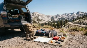 What to Pack for a Highway 108 Road Trip
Packing for Highway 108 is easier when you prepare for both the expected weather and the possibility of delays. Even on a warm summer day, higher elevations can be considerably cooler than Sonora, and wind can make exposed viewpoints feel cold.
Bring drinking water, snacks, sun protection, comfortable footwear, a warm layer, and a basic first-aid kit. A paper map or offline navigation, a flashlight, a vehicle phone charger, and emergency supplies are also sensible additions.
If you plan to hike, carry the equipment appropriate for your route, including sufficient water, navigation, and clothing for changing weather. Do not treat a short roadside stop and a high-elevation hike as if they require the same preparation.
Travelers with children should plan regular breaks and bring extra food, clothing, and water. Pets should be secured safely in the vehicle and provided with water and shade when conditions permit. Never leave an animal unattended in a hot vehicle.
For trips during spring, fall, or winter, check the forecast for both the foothills and the summit area. A single forecast for Sonora may not reflect conditions at nearly 10,000 feet.
Where to Stay Along the Highway 108 Corridor
The right overnight location depends on whether you prefer small-town convenience, a forest retreat, or a longer mountain adventure.
Sonora is a practical base for travelers who want restaurants, shops, lodging options, and access to other Tuolumne County attractions. It also works well for visitors who plan to explore the Gold Country before heading toward the Sierra Nevada.
Twain Harte and nearby mountain communities provide a different atmosphere, with forested surroundings and access to outdoor recreation. These locations can be attractive for couples, families, and travelers seeking a quieter getaway.
Pinecrest and the surrounding recreation area may suit visitors interested in spending more time near the lake and forest. However, campground availability, lodging operations, and seasonal facilities vary, so reservations and current operating information should be checked in advance.
For travelers continuing east, lodging choices may be available in communities beyond the pass when the route is open. Plan your overnight stops around realistic driving times rather than assuming that every mountain segment can be completed quickly.
If your goal is photography or hiking, consider staying overnight rather than attempting to fit the entire journey into a single day. Extra time makes it easier to respond to changing weather and enjoy the places you visit without rushing.
Responsible Travel in the Sierra Nevada
Highway 108 travels through a landscape that supports wildlife, forest ecosystems, waterways, and popular public recreation areas. Responsible travel helps preserve these places for future visitors.
Use designated parking areas, respect road closures, and avoid driving on unapproved tracks or fragile meadow surfaces. Pack out all trash, including food wrappers and small items that can easily blow away in the wind.
When camping, follow the regulations for the specific site and check whether campfire restrictions or fire permits apply. Conditions can change during wildfire season, and a fire that seems manageable in one location can become dangerous when wind and dry vegetation are present.
Wildlife should be observed from a safe distance. Do not feed animals or leave food accessible, and follow any food-storage requirements in campgrounds and recreation areas. Feeding wildlife can change natural behavior and create risks for both people and animals.
Visitors should also respect other people’s experience of the mountains. Keep noise at a reasonable level, give hikers and cyclists appropriate space, and leave scenic locations as you found them.
For additional information about recreation sites along the upper Highway 108 corridor, consult the U.S. Forest Service guide to Highway 108 day-use areas. It provides official information about recreation opportunities and conditions in the Stanislaus National Forest. <Cite refs={[“turn823201search8”]}/>
Suggested One-Day Highway 108 Road Trip Itinerary
A one-day trip can be rewarding when the pass is open, the weather is suitable, and you start early enough to leave room for stops. The key is to select a manageable number of destinations instead of trying to see every attraction along the corridor.
Begin in Sonora with breakfast, fuel, and a final review of the road report. Continue through Twain Harte and Mi-Wuk Village, allowing time for a brief stop if you find a suitable public area or local business you want to explore.
As you travel farther east, enjoy the forested scenery and consider a stop near Strawberry where access and parking allow. Continue toward Pinecrest Lake if you want a longer break for walking, photographs, or a picnic.
Afterward, proceed toward Kennedy Meadows and Sonora Pass only if the road is open and conditions remain suitable. Allow plenty of time for slower driving, safe pullouts, and the return journey. A trip that includes the lake and summit may take substantially longer than the driving distance alone suggests.
If the pass is closed or the weather becomes unfavorable, adapt your itinerary. You can still enjoy the western Highway 108 corridor and its communities without attempting the closed section. The quality of the trip depends on making sensible decisions, not reaching a particular summit at all costs.
Travelers who want to continue into the eastern Sierra should verify that the entire crossing is open and identify a suitable return route before setting out. Avoid planning a one-way journey that depends on a mountain pass remaining open without confirmation.
Frequently Asked Questions About Highway 108 and Sonora Pass
Is Highway 108 a scenic drive?
Yes. Highway 108 offers a changing mix of foothill communities, forested mountain roads, recreational lakes, river scenery, rugged granite slopes, and high-elevation views. The Sonora Pass section is particularly memorable for its alpine landscape and dramatic terrain.
How high is Sonora Pass?
Sonora Pass is approximately 9,624 feet above sea level. Its elevation contributes to cooler temperatures, seasonal snow, and road conditions that can differ substantially from those in nearby lowland communities.
When is the best time to drive Sonora Pass?
Summer is often the most practical season for a complete crossing, but the actual opening period varies each year. Spring reopening dates depend on snow removal and road safety, while early winter weather can cause closures in fall. Always check official highway reports before departing.
Can you drive across Sonora Pass in winter?
No, not when the seasonal closure is in effect. The pass closes because of snow and hazardous conditions. Lower sections of Highway 108 may still be accessible, but travelers must confirm which sections are open and must not bypass closure gates.
Are there places to stop along Highway 108?
Yes. Sonora, Twain Harte, Mi-Wuk Village, Strawberry, Pinecrest Lake, and areas near Kennedy Meadows provide different opportunities to explore the corridor. Access, parking, operating hours, and seasonal availability vary by location.
Is Highway 108 suitable for RVs and trailers?
Some sections may be manageable for recreational vehicles, but the steep grades, sharp turns, narrow lanes, and limited shoulders near Sonora Pass can make the upper route challenging. Research the specific vehicle and trailer combination before attempting the crossing, and consider an alternate route when appropriate.
Do I need to hike to enjoy Sonora Pass?
No. The scenic drive itself is a major attraction, and travelers can appreciate the mountain environment from suitable designated stopping areas. Hiking adds another dimension to the experience, but it requires extra preparation and attention to trail conditions.
What should I check before leaving?
Review the official Caltrans road report, the weather forecast for the summit and both sides of the mountains, any relevant forest or recreation alerts, and the operating status of places you intend to visit. Make sure your vehicle is ready for mountain driving and that you have enough fuel, water, food, and warm clothing.
Final Thoughts: Make Highway 108 Part of Your Next California Adventure
A road trip along Highway 108 and Sonora Pass is an opportunity to experience the remarkable variety of Tuolumne County and the Sierra Nevada. From Sonora’s historic character and the forested communities of the western corridor to Pinecrest Lake and the rugged scenery near the summit, the route offers memorable experiences for travelers who enjoy exploring at their own pace.
The best journeys combine scenic stops with sensible planning. Check road conditions, allow enough time for the drive, prepare for elevation and changing weather, and remain flexible when seasonal conditions affect access. These simple decisions can help you enjoy the mountain landscape while keeping safety at the center of the trip.
Whether you are planning a summer weekend, a photography outing, or a longer California mountain adventure, Highway 108 offers a rewarding way to explore the natural beauty and local character of Tuolumne County. With the right preparation, the journey can become one of the highlights of your Sierra Nevada travels.